


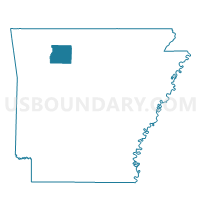
White Voting District, Newton County, Arkansas
About
Outline

Summary
| Unique Area Identifier | 527456 |
| Name | White Voting District |
| County | Newton County |
| State | Arkansas |
| Area (square miles) | 36.41 |
| Land Area (square miles) | 36.20 |
| Water Area (square miles) | 0.21 |
| % of Land Area | 99.43 |
| % of Water Area | 0.57 |
| Latitude of the Internal Point | 35.94712420 |
| Longtitude of the Internal Point | -93.10697500 |
Maps


Graphs
Select a template below for downloading or customizing gragh for White Voting District, Newton County, Arkansas


Neighbors
Neighoring Voting District (by Name) Neighboring Voting District on the Map
- Big Creek Voting District, Newton County, AR
- Dogpatch Voting District, Newton County, AR
- Hasty Voting District, Newton County, AR
- Hudson Voting District, Newton County, AR
- Jackson Voting District, Newton County, AR
- Pleasant Hill Voting District, Newton County, AR
- Polk Voting District, Newton County, AR
Top 10 Neighboring County Subdivision (by Population) Neighboring County Subdivision on the Map
- Jackson township, Newton County, AR (1,620)
- Grove township, Newton County, AR (907)
- White township, Newton County, AR (830)
- Pleasant Hill township, Newton County, AR (386)
- Hudson township, Newton County, AR (327)
- Hasty township, Newton County, AR (268)
- Big Creek township, Newton County, AR (244)
- Polk township, Newton County, AR (224)
Top 10 Neighboring Unified School District (by Population) Neighboring Unified School District on the Map
- Jasper School District, AR (5,912)
- Ozark Mountain School District, AR (5,101)
- Deer/Mount Judea School District, AR (2,393)